Landscape histories from the air:
unlocking a UK-wide archive
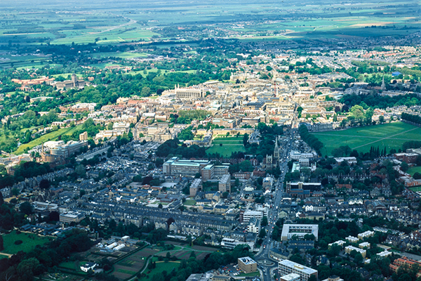
Cambridge University’s Collection of Aerial Photographs, CUCAP, represents a unique, long and proud tradition of aerial survey and interpretation in the British Isles and Europe, started by the pioneering Roman archaeologist JK St Joseph. Much of the imagery is remarkable, of great technical interest (e.g. early colour aerial photography), of high academic value, including as it does records of coastal change, discoveries of archaeological sites and the pre-and post-industrial landscapes of Britain. The total assemblage of hard copy images, dating from 1945 to 2009, comprises 497,079 aerial images. The Collection includes both vertical and oblique aerial views of British landscapes, in both black and white and colour, and slides.
The Collection came to the Department of Geography in October 2000 on the closure of the University’s Air Photography Unit, and was subsumed into the Unit for Landscape Modelling (ULM). Following the closure of the ULM in 2010, the Collection was saved from disposal by a project using the proceeds from the sale of the ULM’s aeroplane and associated equipment. It soon became apparent that whilst the original negatives and slides, themselves were under expert curation, the Collection was difficult to access, except to a small band of professional and enthusiastic ‘aerial archaeologists’ (based in Royal Commissions and English Heritage (now Historic England)). Between 2012 and 2016, funded by the Department of Geography, the ‘front end’ of the Collection was thoroughly overhauled and modernised. Remedial work on the catalogue (such as the removal of some 28,000 duplicate entries from the corrupted database inherited from the ULM) is now substantially complete, and linked to state-of-the-art online mapping technologies. These innovations are based around a new website with a ‘ modern’ URL. From this page it is now possible to: i) browse the catalogue with over 450,000 clickable locations. There are now over 80,000 thumbnail digital scans of selected images, with wide geographical coverage over the whole of the UK (only the Historic England’s National Monuments Record aerial photography collection holds as many digital images, the Cambridge collection is thus the second largest in the UK); ii) search the catalogue by image caption; by themes; and by geographical area; and iii) see some of the very best images in the collection showcased under the headings of coast, ancient Britain, transport networks, castles and stately homes, docklands and the post-industrial north.
Now the ambitious vision is for the long-term digitization of the entire Collection of half a million images. Such a strategy offers the possibility of opening-up a valuable, and in many ways unique, resource to scholars, both in Cambridge and beyond, and the possibility of a much enlarged revenue stream to give long-term sustainability to the maintenance of the Collection. And Open Access to medium resolution imagery for all those interested in UK aerial photography will enhance the University’s reputation as a centre for the study of landscape history.
It was thought sensible to undertake a pilot project to explore how best to digitize the Collection and store the digital images, to see how long it might take and how much it might cost. A scoping exercise revealed that the Cambridge Digital Library (CUDL), the University’s established platform for the output of digital humanities projects, was ideally placed to undertake the trial and University funding was found to take this forward.
Our initial release consists of c.1,500 high resolution zooming images, with accompanying descriptions indicating exactly where and when the photograph was taken. The images are openly available without a need for login or subscription, and lower resolution images can be downloaded through the site for research or educational use. The images are also being made available using the innovative International Image Interoperability Framework (IIIF) technology which opens up the collection for digital analysis by researchers. The whole site is searchable, giving users a quick and easy way to find, for instance, all images of a particular place or feature. As more content is added users will be able to navigate a huge variety of images from this fantastic archive in extreme detail, and we are sure that the collection will be of interest to a very wide audience in academia, interested amateurs and the general public.