
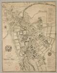
A new plan of the University and town of Cambridge to the present year 1798 (Maps.bb.53.79.1)
Cambridge, William Custance, 1798.
William Custance was a builder, land agent, surveyor and enclosure commissioner who by 1801 was living in Chesterton and was employed by many Cambridge colleges to compile maps and provide surveys and valuations of them.
His map gives a very clear picture of Cambridge just before the major changes that were to take place in the early part of the nineteenth century. Although the outline of the city had changed little, further intensification of building can be seen – especially in the centre of the town where virtually all open land has now been built on.
Information about this document
- Physical Location: Cambridge University Library
- Classmark: Maps.bb.53.79.1
- Publisher: Surveyed by and published for W'm Custance
- Place of Publication: Cambridge
- Date of Publication: May 21st 1798
- Language(s): English
- Note(s): Scale: Scale approximately 1:4,000; Coordinates: (E 0°06ʹ10ʺ--E 0°08ʹ21ʺ/N 52°12ʹ59ʺ--N 52°11ʹ36ʺ)
- Extent: 1 map ; 46 x 36 cm
- Material: Paper
Want to know more?
Under the 'More' menu you can find metadata about the item, and information about sharing this image.
- Physical Location: Cambridge University Library
- Classmark: Maps.bb.53.79.1
- Publisher: Surveyed by and published for W'm Custance
- Place of Publication: Cambridge
- Date of Publication: May 21st 1798
- Language(s): English
- Note(s): Scale: Scale approximately 1:4,000; Coordinates: (E 0°06ʹ10ʺ--E 0°08ʹ21ʺ/N 52°12ʹ59ʺ--N 52°11ʹ36ʺ)
- Extent: 1 map ; 46 x 36 cm
- Material: Paper
Information about this document
Share
You can also embed the viewer into your own website or blog using the code below:
