Maps
A map says to you, 'Read me carefully, follow me closely, doubt me not.' It says, 'I am the earth in the palm of your hand. Without me, you are alone and lost .'Beryl Markham, West with the Night
Maps are powerful objects, created and used for many varied reasons. They can be works of art, a means of propaganda, reflections of power and status, or tools for navigation. They give you the chance to follow the footsteps of those who lived centuries ago and to view the structures that would have been visible to them at the time.
By some estimates as much as 80 per cent of information circulating in the world is related to geospatial location. To gain the most from that information you will probably need to know more about that place – where it is; what it is like; how it relates to other locations; how it has changed through time. The Map Department of Cambridge University Library with its 1.3 million maps and over 40,000 atlases and books on cartography can help you to answer these questions (and many more).
The printed and manuscript maps and atlases in the Map Department cover the whole world in a range of scales, from detailed topographic maps showing the lie of the land and the man-made features resting upon it, to world maps showing ocean currents or time zones. The maps were compiled for a variety of purposes – through propaganda to art and science – and show different types of information, like geology, climate, transport, streets and historical events. Items in the collection range in date from the 15th century to the present day and as well as being used to tell the history of a place, they can be studied in their own right as works of art, as reflections of the society in which they were made, as a means of understanding how such items were made and why.
Highlights include:
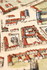
- Plans showing Cambridge at different dates from the first complete plan of the city in 1574 by Richard Lyne to William Custance’s map of 1798 , before the great changes that affected the city during the early part of the 19th century. Look at the following: Richard Lyne, 1574 ; Braun & Hogenberg, 1575 ; Valesio, 1595? ; John Speed 1611/1612 ; Thomas Fuller, 1634 ; Wenceslaus Hollar ?, 1640 ; David Loggan, 1688 ; David Loggan / Henry Overton, ca. 1715 ; Pieter van der Aa, ca. 1720 ; 1763 ; 1791 ; William Custance, 1798 .
- John Speed’s maps of the counties of Great Britain (Atlas.2.61.1). Proof maps prepared for John Speed’s atlas which was published in 1611/1612. For more information see our web pages .
- Three spectacular maps of parts of Burma painted on cloth in about 1860 (Maps.Ms.Plans.R.c.1-3). The largest of these maps measures 405 x 259 cm and may well be the largest single item in the Cambridge Digital Library!
- Cambridge University Library’s only Portolan chart (an early sea chart). This one is of the Aegean Sea and part of the Eastern Mediterranean and was drawn in about 1650 (Maps.Ms.Plans.697).
-
Over 300 manuscript maps from the Map Department’s collection including many 19th and early 20th centuries maps of parts of Cambridge.
- The earliest maps in this tranche of images (more will be added later) are a fantastic 1650 map of Uggeshall in the county of Suffolk (Maps.Ms.Plans.904) ; A 1666 map of part of the Common belonging to the Cittie of Eley (Maps.Ms.Plans.120) ; and the meticulously drawn mapp of Wolstaston Wood in the county of Salop (Maps.Ms.Plans.990).
- 18th century maps include a 1726 survey of Bulphan Hall , Essex with a drawing of the church (Maps.Ms.Plans.1001) ; a 1736 map of certain lands in the parish of Stone in the Isle of Oxney in the county of Kent with key (a fairly unusual feature on maps of the period ; (Maps.Ms.Plans.1027) ; a 1737 plan of Beaumonts Hall Farm in Suffolk (Maps.Ms.Plans.1026) with fantastic putti adorning the scale bar ; a 1754 map of “lands belonging to the Revrd. Mr. Saml. Knight lying in the parish of Willingham in the county of Cambridge” (Maps.Ms.Plans.18) ; a 1755 plan of Mr Wardley's estate at Worlingworth, Suffolk (Maps.Ms.Plans.986) and a 1776 map of an estate in Mildenhall , Suffolk (Maps.Ms.Plans.7).
- Some maps include the names of land owners, such as a plan of the parish of Rampton , drawn in 1837 (Maps.Ms.Plans.42).
- Some maps show College lands such as the 1820 Plan of an estate belonging to the Master and Fellows of Caius College in Cambridge in the parishes of South Runcton and Holme, Norfolk (Maps.Ms.Plans.1071).
- And, of course, many of the areas have now changed. Look, for example, at the map of pasture lands in the area now known as Brookside ( Maps.Ms.Plans.62(d) ) and plans of the area around Thompsons Lane in Cambridge , an area at one time occupied by a coal yard and an orchard and now known as Quayside.
- Plan of Cambridge market in 1836 ( Maps.Ms.Plans.76 ).
- Plans of the Old Botanic Gardens , Free School Lane and Pembroke Street.
- A wonderfully evocative map of Greece (Maps.Ms.Plans.3).
- Plans of military locations and events such as a bird's-eye view pictorial map depicting the siege of Landau , 1742 (Maps.Ms.Plans.991) ; Plan of the town and harbour of Dunkirk with the new canal and sluices built by the French in the year 1753 (Maps.Ms.Plans.989) ; Plan of the two encampments in the neighbourhood of Bury St. Edmunds , ca. 1780 (Maps.Ms.Plans.987).
Maps can also be found in other Digital Library collections such as Treasures , Waterloo , Board of Longitude and the Royal Commonwealth Society collections and have a look at Lancelot 'Capability' Brown’s map of The Backs at Cambridge (UA P.I.3)
